Engagement
1. Purpose of the Exhibition
Supporting the delivery of the new community
Welcome to this public engagement event for the Wychavon Town Strategic Transport Infrastructure project. This is the movement network that will ensure the infrastructure is in place to enable the development of Wychavon Town, the proposed new community near Worcestershire Parkway of around 10,000 homes and 50 ha of employment land, extensive green spaces, new schools, community facilities and a town centre.
The event provides an opportunity for people to:
- Learn more about the strategic movement infrastructure.
- View early design proposals showing how new and existing residents will move around and through the new town, including links with existing communities
- Share feedback and help shape the design of the infrastructure as it develops
Setting the Framework for a growing community
The proposals are about more than just infrastructure; the aim is to support a sustainable and well connected community as Wychavon Town takes shape.
The success of Wychavon Town will be connected to its ability to deliver the needed infrastructure, services and facilities at the right time to meet the needs of the new communities as well as supporting the existing residents and communities and how they get around the local area.
This approach is essential to accommodating new homes while maintaining network capacity, reducing congestion and improving quality of life.
The proposals are for 4 neighbourhoods of the Town, and include:
- Western Neighbourhoods
The Pershore Boulevard connecting the M5 Junction 7 eastwards towards the Town Centre and Worcestershire Parkway Station - Town Centre
A new railway bridge for everyone to use and access routes around and through the proposed town centre - Southern Neighbourhoods
A new underpass under the railway for walking and cycling and a new bypass around Stoulton to reduce traffic through the village and provide access the development - Eastern Neighbourhoods
A new primary route connecting Pershore Road (B4084) in the proposed town centre and the A44
Wychavon Town is allocated in the South Worcestershire Development Plan Review (SWDPR) for 10,000 homes with 5,000 expected to be built before 2041.
Wychavon District Council aims to adopt the Spatial Framework SPD for the town on 24 June.
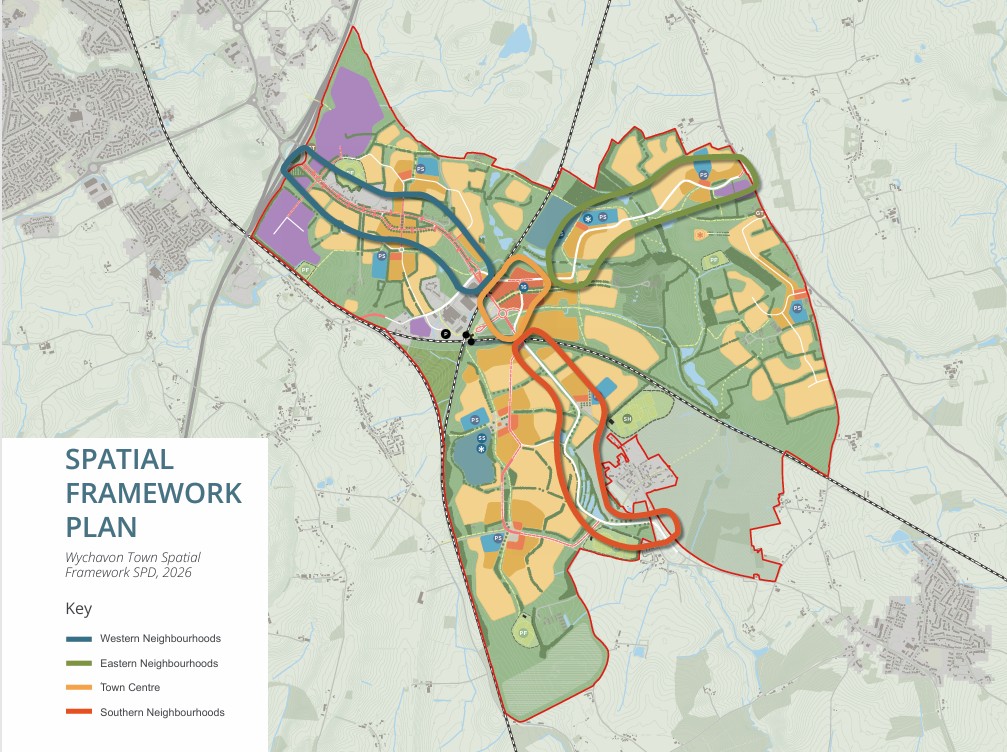
The vision in the SPD:
“Wychavon Town will be a place where most journeys can be made by active and sustainable modes, where people can be healthy and active, and places are not dominated by cars. This vision will be achieved through a coordinated movement framework which enables and promotes sustainable movement through the creation of walkable and safe neighbourhoods, an accessible railway station, town centre, schools, and local hubs which enable travel choice, through the use of new and repurposed transport infrastructure.”
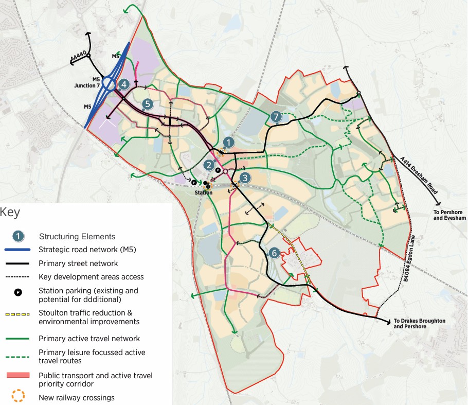
Movement Framework
- A new all-modes bridge over the Birmingham-Gloucester (BAG)/ Cross Country railway line.
- Repurposing the existing B4084 bridge over the BAG line for active travel and public transport.
- A new active travel underpass under the Cotswold railway line.
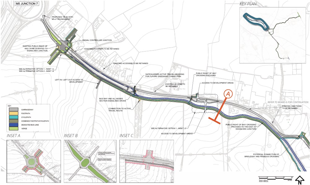
- A new ‘Western Gateway’ junction adjacent M5 Junction 7 to mark the transition into the new town
- ‘Pershore Boulevard’ along the current B4084 between the M5 and around the new town centre.
- A new Stoulton Bypass, to direct Wychavon Town traffic away from Stoulton.
- A new A44 Link Road to connect the new town centre and eastern neighbourhoods to the A44.
3. Design Approach
A movement that puts people first
The proposals prioritise walking, cycling and public transport as the most attractive and efficient ways to travel within and around the new community so that people have genuine options other than using cars.
Walking Routes - Walking routes including priority crossings will connect neighbourhoods, public rights of way, bridleways and key destinations across the site.
Cycling Infrastructure - Dedicated cycle routes will provide direct and accessible connections.
Priority Routes - Priority lanes and routes for buses will allow bus services to be attractive and efficient.
Safer Junctions - Safe junctions, crossing points and road layouts encourage lower vehicle speeds.
Attractive Public Realm - An attractive and safe environment through landscape and public area focussed design.
This approach supports the wider vision for Wychavon Town by encouraging healthier and more sustainable travel choices.
Responding to existing landscape and environment
This approach supports the wider vision for Wychavon Town by encouraging healthier and more sustainable travel choices.
- Work with existing landform and vegetation
- Retain important landscape features
- Integrate transport with green and blue infrastructure
- Protect the setting of historic features
- Consider the impact on local residents and communities
- Enhance biodiversity and visual quality
4. Concept Design Proposals
The concept design establishes the form and function of movement corridors including key junctions and crossings.
We have arrived at the preferred design after considering a wide range of options and road alignments in each neighbourhood. These have been tested for:
- How they fit with the SPD and movement strategy
Impacts on the landscape, environment and local communities - Safety and efficiency
- How they might be delivered
- How they relate to the development proposals
An initial view on traffic modelling has formed part of the consideration and further modelling will be available at the next stage of design.
Key Design Components
Across the route, a series of key design features and nodes have been developed to support movement and placemaking.
5. Western Neighbourhoods
A strategic gateway
The Western Neighbourhoods form the gateway into Wychavon Town, connecting the new community to the wider strategic road network, including the M5 (Junction 7).
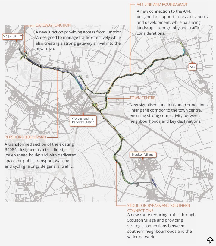
The gateway is key to enabling early phases of the Town and establishing it’s character and function.
A new gateway junction east of the M5 will provide access into the developments to the north and south and into the Town. The design aims to manage traffic efficiently while also establishing a strong sense of arrival.
A traffic signalised junction is proposed as early indications from traffic modelling show that this will manage traffic better, however a roundabout also under consideration if it is found that this is preferred.
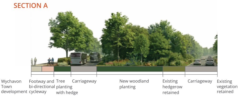
Pershore Boulevard
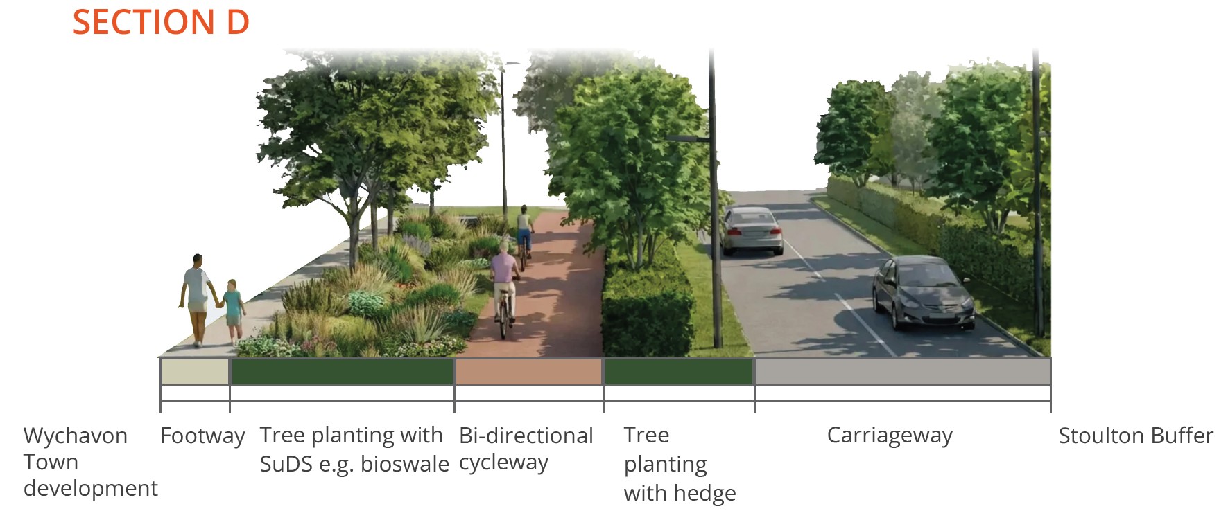
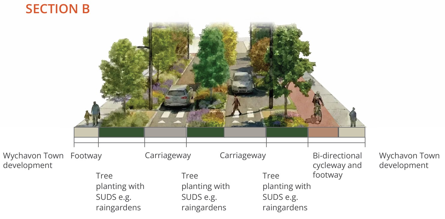
At the heart of the proposals is the transformation of the existing B4084 into Pershore Boulevard, a key multi-modal corridor forming part of the town’s primary movement spine. The boulevard will:
- Introduce the segregation of different forms of movement.
- Provide dedicated space for bus services.
- Maintain access to existing properties while providing connections to new homes, employment areas and community facilities.
- Prioritise walking, cycling and public transport.
- Maintain existing trees and hedges and incorporate new tree planting, SuDS, landscape buffers and high-quality public realm.
- Be delivered early to support travel choice for existing and new residents.
This approach supports the creation of streets that function as both movement corridors and engaging public places.
Woodbury Lane will remain open for vehicles. The new corridor will include a junction at the northern end linking Woodbury Lane to the B4084, the town centre and the A44 link. Public transport will use the existing road, providing a direct access to Parkway Station.
6. Town Centre
The Heart of Wychavon Town
The town centre will form the social, economic and civic heart of Wychavon Town, bringing together homes, services, employment and community facilities in a highly accessible and vibrant location. It will be centred around Worcestershire Parkway Station, creating a strong connection between the new town and the regional and national rail network.
The design reflects the SPD vision for a compact, walkable and well-connected centre, where movement, activity and public life are closely integrated.
Key Connections include:
- A new bridge linking both sides of the railway for all forms of transport
- Improved bus priority on connections to Worcestershire Parkway Station with the existing bridge for buses and active travel
- Access through and around the town centre linking the southern, eastern and western neighbourhoods
- Direct walking, cycling and public transport routes into the centre
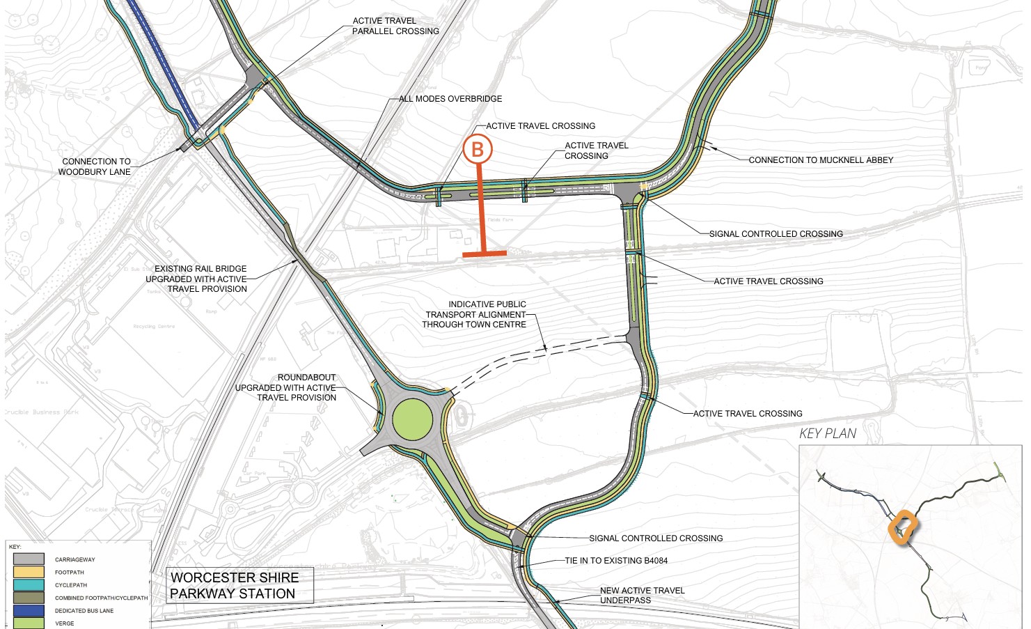
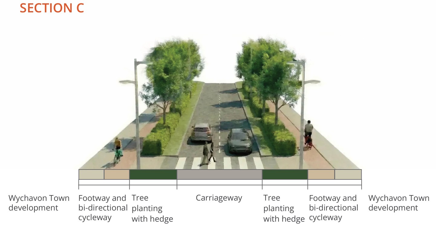
The town centre aims to provide:
- Low-speed streets, supporting safe and people focused movement
- A high street and public square, connected to streets designed as engaging spaces
- Prioritised walking and cycling with direct continuous routes
- Tree planting, landscaping and integrated green and blue infrastructure and prioritisation of quality of place and materials.
7. Eastern Neighbourhoods
A44 link and secondary school access
A new link is proposed from the town centre to the A44. It will:
- Connect the town with the strategic road network using the A44
- Allow for access to new schools, residential development parcels and employment areas
- Include integrated walking and cycling routes allowing easy access towards the town centre, schools and employment areas for all.
- Be designed as a 30mph route with 20mph zones around the schools and local centres.
A44 Roundabout
There will be a new roundabout on the A44 to connect into the town, representing a key gateway junction within the Strategic Framework SPD.
The location design has considered how to deliver the SPD aspirations within the constraints of the existing highway alignment, design standards and visibility requirements, nearby properties, and trees and landscape features.
8. Southern Neighbourhoods
Southern Boulevard
South of the town centre, the existing B4084 will provide the connection between the railway station, the town centre and the southern neighbourhoods and connect to the Stoulton Bypass.
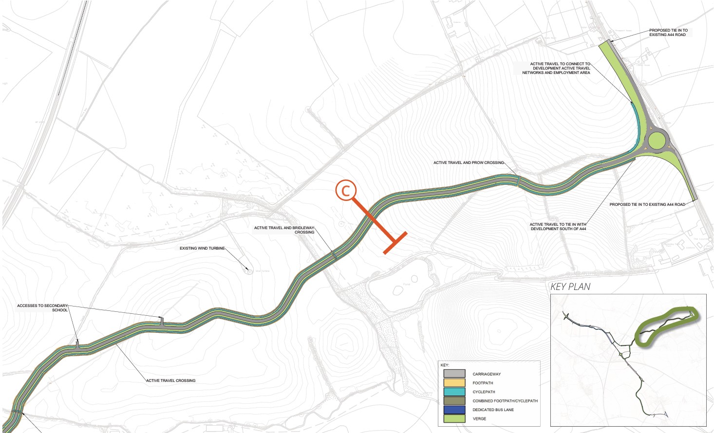
A new underpass of the Cotswold rail line is proposed to improve vehicle access through here and incorporate a high-quality active travel route.
South of the underpass, the segregated cycleway and footway to serve the neighbourhoods is designed to the east of the existing hedgerow, enabling the hedgerow to be retained. New walking and cycling routes through the southern neighbourhoods will be designed and come forwards as part of the development parcels and their own planning applications.
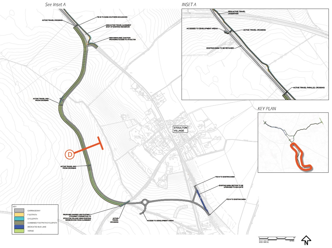
Stoulton Bypass
The Stoulton Bypass is a proposed diversion of the existing B4084 around the village of Stoulton with the objective of reducing the existing and future impact of the development on the historic settlement by diverting the main flow of traffic away from it.
It is proposed that the speed limit will be reduced from the national speed limit to 40mph from the south of Stoulton to a proposed roundabout, with the rest of the link being 30mph towards the Southern Boulevard.
The roundabout will serve development in the southern neighbourhoods.
This new road will take the existing traffic from Wadborough Road away from Stoulton village. Instead, the old road will be used for walking and cycling for new and existing residents. This change will not take place until the new road is in place and open.
We are looking at whether it would be appropriate to introduce a speed reduction to 20mph through Stoulton village.
Next Steps
From concept to detailed design
The concept design presented here provides the foundation for the next stage of work where the proposals will be developed in greater detail. Future work will include:
- Refinement of routes, junction layouts and crossings
- Detailed design of walking, cycling and public transport infrastructure
- How the infrastructure will be built and when so that it minimises the construction impact of the new town on the existing residents and communities
- Integration of landscaping, drainage and environmental mitigation
- Further modelling and technical assessment
Planning Application
Your feedback at this stage is important in helping to shape these proposals as they progress towards a planning application.
The intention is to hold a further public engagement event in the autumn to report on the outcome of detailed design and the form of the fi nal proposed strategic transport infrastructure.
A planning application for the infrastructure proposals will be then submitted to Wychavon District Council in December 2026. You will have further opportunity to comment as part of the statutory planning process.


